Magic Earth sat nav app (Android and iOS)

Yep. All the main providers limit the time in Europe to 2-3 months I think. Some are more lenient than others.

So the diverted and tricky route to our new spot went without a hitch with Google Maps. The road that Magic Earth refused to allow me to use was fine. Bizarre.
 
Yep. All the main providers limit the time in Europe to 2-3 months I think. Some are more lenient than others.

So the diverted and tricky route to our new spot went without a hitch with Google Maps. The road that Magic Earth refused to allow me to use was fine. Bizarre.
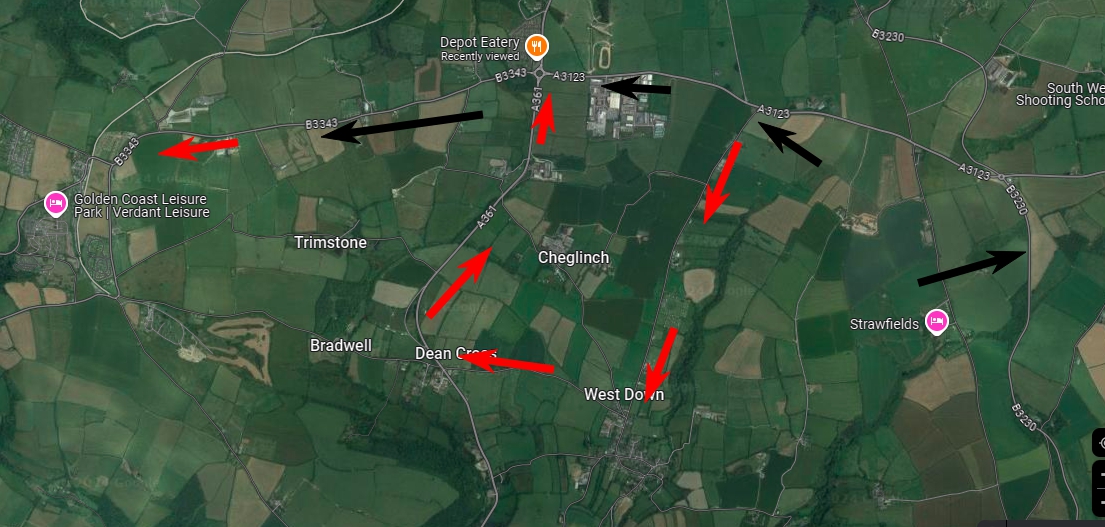
Can you pinpoint the road please? I'll check it on OpenStreetMap.
 
I'll see if I can screen shot it on my laptop later. Or the phone if I can remember how to do it. 😁
If it's a Samsung phone use power off and volume down concurrently. Or failing that try at the same time...
 
If it's a Samsung phone use power off and volume down concurrently. Or failing that try at the same time...

I can do screen shots on the phone (Realme 8) but it dont work in Magic earth. Anyway I tried the route again and its working now but this is what it was doing this morning. The black arrows are the way I wanted to go and actually went but the red arrows is where Magic Earth was forcing me to go. There was a road closure though which was the A361 up to the roundabout which kind of makes it worse as the diversion Magic Earth wanted me to take was actually into the road closure. The black arrows were the correct route which was indeed open.

 
I can do screen shots on the phone (Realme 8) but it dont work in Magic earth. Anyway I tried the route again and its working now but this is what it was doing this morning. The black arrows are the way I wanted to go and actually went but the red arrows is where Magic Earth was forcing me to go. There was a road closure though which was the A361 up to the roundabout which kind of makes it worse as the diversion Magic Earth wanted me to take was actually into the road closure. The black arrows were the correct route which was indeed open.

There's nothing odd about that section of the A3123 that would explain why that route would be excluded.

Weird....
 
There's nothing odd about that section of the A3123 that would explain why that route would be excluded.

Weird....
Is it possible that live traffic is/was out of date? On 10/06/2023, CoPilot told me that the road past the Fleur de Lys was closed, which it most definitely wasn't, but I believe that there had been roadworks there previously.
 
There's nothing odd about that section of the A3123 that would explain why that route would be excluded.

Weird....

Very. The only thing I can think is maybe someone reported or amended the map incorrectly because of the ongoing road closure up the A361 from Braunton to Ilfracombe which is shut from that roundabout where the arrows are on my map to around where the Magic Earth diversion was near West down. The worst thing being is the road they diverted was the wrong one and took you actually onto the road closure. :D Google maps is not necessarily any more accurate (although I suspect usually it is). Google the other week if you remember tried to tell us the road from Boscastle to Tintagel was closed with a massive diversion but it wasnt.
 
Is it possible that live traffic is/was out of date? On 10/06/2023, CoPilot told me that the road past the Fleur de Lys was closed, which it most definitely wasn't, but I believe that there had been roadworks there previously.
Wow Tom!! are you that Anal you made a note of CoPilots mistake, I can barely remember the year never mind an occurrence.
 
Wow Tom!! are you that Anal you made a note of CoPilots mistake, I can barely remember the year never mind an occurrence.
No, but I remembered going there last year and having the issue. (I also had the issue with a road a couple of hundred metres from home that had been affected by resurfacing works while I was away in France.) Quick look in the log to check when I met @Canalsman at the Fleur de Lys...
 
I used to keep notes when we first started this lark but I gave up after a while as I hadn't made use of any of it.
 
You always remember extreme sat nav diasters. Worst one for me was a wrong sat nav turning near lac st Croix in Provence. I knew it looked wrong but I went down the very steep lane anyway. Tried to turn around and almost turned the van over. It looked like a dead end but someone came out of a building and waved us on. So I came down the impossibly steep narrow lane to what looked like a dead end and into a pedestrian road lined with stalls, shops and eateries. The stall holders and waiters hurridly moved tables and racks to let the stupid Ingleeesh motorhomers in the size large motorhome through. I smiled and waved of course as you do and acted like I was doing it on purpose. 😁

Almost as funny was accidentally joining the presidential motorcade on Lake Como.
 
Just discovered that Magic Earth allows import of third party POIs...


Just downloaded the wildcamp POI from here as a test. That all worked but I dont have the green W PNG file. They just appear as grey markers with the name on. Will see if I can find the PNG
 
So. I found the "W" in the downloads but as a BMP not PNG. Downloaded it and converted it to PNG. Then I named it exactly the same name as the KML file. Then I found the folder (not so easy) where the KML file is and stuck the PNG in there but even after restarting the App they dont appear as "W" on my screen

screenshot_678.jpg
Screenshot_2024-09-25-11-36-45-14_d7851dc996985b6b5f97584fae19a35f.jpg
 
Nah. Can't find a way to fix that. It will be a big issue if you start downloading zillions of POI. Aires etc. I might contact them.

So I moved on to see if I could export google maps routes to Magic earth. Two things I learned. Magic Earth has a browser based map like google maps and you can export GPX routes from there but its not great. It plots each point as a lat and long rather than a place name so you quickly get lost when rearranging them. You can export the GPX and then import it into your magic earth app but it never loaded the whole route for me. So I then used a third party app to export a google maps route to GPX and successfully imported the whole route into Magic Earth. However it just comes up as what I think is a cycle route or a dotted line at least and there is no start button. Just Demo.


This the magic earth browser map https://www.magiclane.com/earth

Bit of an fail on all counts really. Below you can see the Google maps route in my laptop browser and the imported map in Magic Earth on my phone. Dont work though as a route. For all this stuff Google Maps is streets (no pun intended) ahead. Getting the POI to work though in Magic Earth would be really good.

screenshot_680.jpg
Screenshot_2024-09-25-12-08-00-03_d7851dc996985b6b5f97584fae19a35f.jpg
 
It seems to me that you need a degree in buggering about to get much out of it Barry.

Yep. I have nothing better to do this morning so thought I would have a play around. It needs a lot of work but so far its the best app I've come across as a sat nav but its still far from perfect or reliable enough. I'm still finding myself googling actual TomTom devices though but I suspect the newer ones will be just as frustrating as the app. They got progressively more tricky as they evolved I think. Map updates were a nightmare and adding POI nowhere near as straight forward as it once was. In the old days you just dragged them into the TomTom folder and that was it. Its annoying as I got my ancient Tom Tom start 20 all set up with all the POI I ever needed but its just too slow, a bit temperamental and the maps are ancient. I might see if I can find an older device with the latest maps on it on ebay.
 

Users who viewed this discussion (Total:16)

Back
Top