Emission zones along a route

GeoffL

Full Member
Posts
2,466
Likes
7,857
We're off to mainland Europe later this year and I'm concerned about the recent proliferation of low emission zones. My MH is over 3.5 tonnes MGW and dates from early 2001, so AFAICT it doesn't qualify for a Crit'Air etc sticker. For France in particlular, it seems it might soon be impossible to get from North to South (or vice versa) without passing through at least one of these zones. So I'm turning to the panel to ask whether there's an easy way (e.g. a website or app) to plan a route that avoids 'active' zones and gives status info for zones that are unavoidable?

Thanks, Geoff

Tony Lee seems to have answered your question before you asked it: Green Zones App

As has mossypossy: Crit’Air sticker
 
Thanks to both. For info, we're booked from Harwich to Hook of Holland for the outward journey and return via the Channel Tunnel. Locations in the Netherlands, Belgium and France are on the itinerary.

I'd already downloaded the Green Zone app, but note that it's already out of date (particulary wrt France) and I find it difficult work with. Potentially better might have been the Urban Access Regulations website router planner. However, that's also out of date and only deals with towns and cities rather than the area-wide zones now in France. So it's of limited help at best. The Crit'Air website has an overview map for France (see here) but, annoyingly, all the zones pop up the text "FrankreichAlle" when clicked rather than the name used by the rest of the website or the Green Zones app.

What I hoped for was something like a layer for Google Maps that could be used to visually check whether a proposed route passed through one or more zones and give the identity of each zone so that I could use the Green Zones app or other tool to determine whether my vehicle would be permitted to pass through.
 
The Green Zone APP just tells you where they are and is just a way of getting you to spend €29 for something you can get on line for less than €5. It certainly doesn’t tell you which ones are active and when. It does appear that you cannot drive a vehicle in some areas without a sticker at anytime and it applies to the main roads as well.

How you find out if they are in use is beyond me. They seem to be suggesting that it will be published in local press / radio which is a great help to the holiday traveler.

So are we going to need yet another device that is programmed daily with all the exclusion zones that are in force that day.

..

As I understand it the Green Zones App is updated to indicate which zones are “active” although you’ll need WiFi to allow the App to update. I agree that there’s no need to buy the sticker via the Crit’Air website, I completed the form on the official website two days ago and this morning received confirmation of my category (Class 3) and advice that the actual sticker would be posted out to my address in the UK. So, when I am travelling through France and should I wish to travel through one of the zones if I check the Green Zones App it should tell me whether I am allowed to travel through that zone on the next day. That’s my understanding anyway.

Pat
 
Geoff, I think the only way to be 100% sure is to avoid France and catch the ferry to Spain:lol-049:
Knowing how the French change things on a whim :danger:
Seriously, I am not going to worry about this issue, Yet!
Lets see what happens!

I do have the French and German stickers, but the transit zones will be a nightmare!

How much did you pay for the German one. We are going through Germany end of April. Had a quick look and it appeared to be around €31. Is that right or did I find a dodgy (do it for you type) website?
 
With these zones appearing quickly and only something’s operative, what is the official way you are meant to know if they are operating. Is it signs on the edge of town?
 
Yep

Phil, from what I read a couple of weeks ago, it will be local radio which is pretty useless to us lot.
Isn't it the sort of thing similar to Paris when they let odd and even number plate vehicles in on different days.
What I mean is a spur of the moment ban when emissions peak to above the desired limit. That is when Paris implement it!
Bl**dy French!

It is all to do with observed pollution levels
I am not sure that a single day with high readings will trigger restrictions.
Those of use with newer vehicles and a "medium sticker" may well find that there is only a problem with high pollution readings/
Those with older or bigger vehicles will have more of a problem.
As has been posted pollution is mainly cased by Factories Power stations etc (and cows).
The weather also plays a huge part in either dissipating the pollution or concentrating It.
Thus I can see a scenario such as
Today restricted
Tomorrow OK
How this gets communicated to the locals is a problem and for us ?
 
AFAICT, ZPA status for the following day is published by 20:00 the previous day. Some zones are activated after a number of days of high pollution (e.g. the Paris ZPA is activated on the 5th day of high pollution) while some are activated immediately (e.g. Vendee, where the first measure is a 20kph reduction of speed limits and may be combined with other restrictions).

As to how you find out, the Green Zones app gives the information provided you have an Internet connection -- you click the Show Access Status button at the bottom of the page for the zone in question. Another apparent way is via the Crit'Air website (Inform yourself now about the French Vignette Crit’Air!). To access this information, hover your mouse over the Information about the Crit'Air Vignette link to open a drop-down menu of zones. In this menu, click the link for your zone to reveal status information. Note that you can page through the dates by clicking the arrows at each side of the date bar (although how they can say before a publication deadline whether you're allowed to drive escapes me). Also, what happens if they spring a prohibition on you while you're transitting the area?

... and I still haven't found a way of easy route planning to avoid active zones. It looks like I need to spend half an hour or more the evening before to determine the status of relevant zones.
 
Yes

But a bit of a "Cheval de Nuit"...
If the police stop and question you you simply respond " Eh Oh! Eh Oh! Eh Oh! Quest que c'est...... Pardon je suis Anglais" !!!
Hiding now !
 
Here's a grab from the German website.

Is my sticker only valid in Berlin?
The sticker is not only valid in Berlin but in all environmental zones throughout Germany. Around 80 German cities have already established environmental zones. The (website of the Federal Environmental Agency (Umweltbundesamt – UBA) gives an overview of environmental zones in Germany.


So I would say that is a definitive answer.

Cheers

H
 
Well I found a comment box on their website so I have told them that I speak very little French so don't listen to radio and don't read newspapers so how am I as a traveller to their country going to know where I can drive. Will wait for reply :sleep-027:
 
Sorry Guys, but this thread is getting more and more like groundhog day
The emission thing for Germany has been applicable for a few years now, so nothing new and there are threads and threads about it and has anybody thought of Mr Google. All the information is there.
The same goes for the French version!
The German one is for Germany as a whole, but people please check properly and don't rely on hear say from a forum!

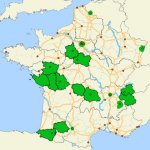
Er... as the OP, I posted my question because of very recent changes in France. AFAICT, the majority of ZPAs were introduced in the latter part of last year and the swathe that stretches inland from the Vendee to Clermont-Ferrand and beyond only became an issue this year. Compare the half-dozen French, city-based zones that existed at the beginning of last year with the following map:

France.jpg

Until this year, you could simply plan your route to avoid all emissions zones but, as these zones proliferate, that's becoming more and more difficult. I was hoping that something like a sat nav app existed that would allow you to create routes that avoid active emissions zones in the same way that most allow you to avoid tolls, motorways, etc. However, it seems that you still need to do this the long-winded way. As my MH is 'class 0', I'll probably be one of the first forbidden to drive when a zone becomes active and so this topic is probably more important for me that someone who qualifies for 'class' 1, 2 or 3!
 
We're off to mainland Europe later this year and I'm concerned about the recent proliferation of low emission zones. My MH is over 3.5 tonnes MGW and dates from early 2001, so AFAICT it doesn't qualify for a Crit'Air etc sticker. For France in particlular, it seems it might soon be impossible to get from North to South (or vice versa) without passing through at least one of these zones. So I'm turning to the panel to ask whether there's an easy way (e.g. a website or app) to plan a route that avoids 'active' zones and gives status info for zones that are unavoidable?

Thanks, Geoff

PSSST!!!!! Do you want a quick photcopy, in colour of mine with a blank for the number plate????????????????

Brown envelope to XXXXXXXXXXX , give it later. SHHHH!
 
How much did you pay for the German one. We are going through Germany end of April. Had a quick look and it appeared to be around €31. Is that right or did I find a dodgy (do it for you type) website?

I think I paid, 4 euros or so, not a lot anyway. DO NOT BELIEVE THE WEBSITES offering to get them for you, they are rip off site.
PS see above, see me around the corner in a moment.
 
How much did you pay for the German one. We are going through Germany end of April. Had a quick look and it appeared to be around €31. Is that right or did I find a dodgy (do it for you type) website?

I think I paid, 4 euros or so, not a lot anyway. DO NOT BELIEVE THE WEBSITES offering to get them for you, they are rip off site. You can get them a most main dealers in Germany and the ADAC or the ministry sites.
PS see above, see me around the corner in a moment.
 

Users who viewed this discussion (Total:0)

Back
Top