We are now back from our 30 nights in Ireland, plus one in Birkenhead on the way out. The ‘plan’ was to follow the Wild Atlantic Way (WAW) anti-clockwise from Kinsale. We visited all the major points but did not explore some of the minor peninsulas and side roads. The weather was pretty bad - it rained everyday apart from about three days, which were mainly at the end of the trip, but it did not rain all day, at least not every day. There was an almost constant strong bitter cold wind. Talking to locals the weather is not typical for April. Potatoes are usually planted on St Patrick’s Day, March 17th, but this year it was too cold. We heard a lot on the radio about the ‘fodder crisis’. Due to a long winter farmers are running out of silage and because spring has come late and has been wet there is no grass for the cattle so they need to be fed silage for longer. With better weather we would have stopped longer at some places and would have done more walks. So to explore the whole WAW and the Causeway Coastal Route in a relaxed way it could easily take twice as long - 60 days. We did 1,780 miles (2,864 km) in Ireland plus 470 miles to and from Birkenhead.
There are 159 WAW Discovery Points, some on offshore islands, of which 15 are Signature Discovery Points. It is possible to overnight at most of the Discovery Points.
Most beaches have public toilets but we never found any that were open. Toilets in harbours and in towns are typically closed at night.
We saw some height barriers, and also some car parks where the barriers were open, and also ‘no overnight’ signs. These were rarely at places we wanted to stay.
Here is where we stayed, with ratings out of 10, and what we did.
Birkenhead Ferry Terminal, 55.40617 -3.01775 2/10
We arrived late in the area, asked at the reception and were given the ok to stay overnight for our 10:30 ferry the next day. Reasonably quiet at the far end away from the terminal building and convenient.
Millisle, 54.60175 -5.52399 4/10
Convenient for the first night when arriving in Belfast on the ferry and heading south. Large car park overlooking the sea. From here we visited Mount Stewart National Trust house on our way south.
Spegla Dam, Mourne Mountains, 54.179227, -6.058719 8/10
Good views over reservoir. Butter Mountain short walk, 2.2 km round trip.
Drogheda, 53.7301 -6.2601 5/10
Dead end road on the River Boyne, outside gates to boat yard. Not a lot of space but enough for one van on the left of the gates and perhaps another tucked in. From here we visited: Bru Na Boinne, visitor centre for Newgrange and Knowth, Neolithic passage tombs.
Lowtown Marina, 53.27528 -6.83522 5/10
Parking overlooking the junction of the Grand Canal and Barrow Line. Toilets open during the day, automatically locked at night. Water and showers need a card to access. From here we drove to Cobh.
Cobh, 51.846797, -8.309349 6/10
Full service aire overlooking the harbour. Services free. Parking 10 euros / 24 hours. Interesting heritage town. From here we visited Cork by train, station five minutes’ walk away, 10 euros / 25 minutes.
Kinsale Charles Fort, 51.69778, -8.498832 7/10
Car park and road side parking areas on a bit of a slope, we parked on the road side which was a bit more level. Office of Public Works (OPE) sites have free admission on the first Wednesday of the month. From here we started the Wild Atlantic Way (WAW) visited: Charles Fort, Old Head of Kinsale and Timoleague Abbey ruins.
Drombeg Stone Circle, 51.56592 -9.08638 3/10
Car park has height barrier. As it was late we parked outside off the road and without blocking the entrance. Bronze Age 17 stone circle worth a visit. From here we here we visited: Ballydehob with its old railway viaduct, Schulz and Mizen Head (in force 9 gale).
Bantry (2 nights), 51.681235, -9.455567 6/10
The harbour car park near the town square is closed 6-9am on Friday for a market. The CP has height barriers but they were open. We parked along the road overlooking the harbour outside SuperValue. There is a town heritage walk, also short walks starting from the town, a helpful tourist office (with WiFi) and music in some of the pubs in the evening. From here we visited: Castletown Bearhaven - ‘Ireland’s fishing capital’, Loughane More Ring Fort, Beara Peninsular with Dursey Island cable car, and Allihies and Eyeries - two villages with colourful houses.
Kilmakillogue, 51.783055, -9.820912 6/10
WAW Discovery Point. Car park overlooking Kilmakillogue harbour and Kenmare River. Off the road and quiet. Not very level but great views. From here we visited: Kenmare and Sneem - with sculpture trail.
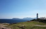
Coomanaspic, Skeilg Ring, 51.856189, -10.367023 8/10
WAW Discovery Point. Wide area of hard standing off the road where a track goes up to a radio mast. Not very level but ok when parked on edge of area. Great views of the Skeilg islands. From here we visited: the Skeilg Experience Centre, Ballycarberry Castle ruins and Cahergall Stone Fort.
Dingle (2 nights), 52.139099, -10.276236 5/10
Car park by harbour and tourist office, free between 18:00 and 08:00. Toured the Dingle peninsular. Great walk, parking at Slea Head, to Dunmore Head with views of Blasket Islands. Lots of view points. After the second night in Dingle we visited: Connor Pass viewpoint but thick mist so no views, some very narrow section of road on way down, north via the Tarbert to Killimer ferry, Carrigaholt castle ruins and a roofless church at Cross.
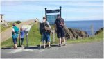
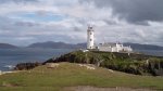
Loop Head, 52.560991, -9.930457 7/10
WAW Discovery Point. Car park outside lighthouse. Walked around Loop Head, then from here visited: Bridges of Ross and Kilkee Cliffs - all with great views, and Bridget’s Well.
Cliffs of Moher, 52.972278, -9.42237 4/10
WAW Discovery Point. Overnight in the car park and next day went to see the cliffs. It may be one of Ireland’s top tourist attraction with 1.5 million visitors a year but we enjoyed the views more from the previous days. The day we visited it was quiet with only around 2,000 visitors, the midges were also out in force. From here we drove through the Burren - bleak but beautiful limestone area.
Coromore Abbey, 53.126959, -9.053806 6/10
Down a quiet no through road, but still visited by tour buses. Flat. From here we drove across the blanket bog between Derryrush and Gowla with peat turf cutting in progress.
Glynsk Bay, 53.37467, -9.840993 6/10
WAW Discovery Point. Flat parking above a small harbour. Water tap on harbour wall. From here we visited Roundstone and the excellent Derrigimlagh 5km walk with interpretation of Marconi’s site of the first broadcast across the Atlantic and Alcock and Wright’s landing after the first ever transatlantic flight and more turf cutting.
Leenaun, 53.60007 -9.72973 7/10
Flat parking on the fjord like Killary Harbour where Killary Fjord Boat Tours depart from here we visited Aasleagh Waterfall (overnight parking close by), Doolough Memorial to famine victims, the National Famine Memorial and Westport.
Raheens Wood, Castlebar, 53.84605 -9.35738 4/10
Level parking for wood with walks. Close to straight road so some traffic noise. From here we visited the National Museum of Ireland - Country Life, Turlough Park, 15 minutes away, and Gortnor Abbey Pier, 54.093875, -9.299058, which has water tap and overnight campervan parking.
Downpatrick Head, 54.322735, -9.345536 9/10
WAW Discovery Point. Great views of wild Atlantic with crashing waves and associated salt spray. Walk from here to head with sea blow hole, Dun Briste 40m sea stack and WWII look out. From here visited Killala Round Tower and Glencar Waterfall in full flow.
Donegal (2 nights), 54.652107, -8.112096 5/10
Car park close to town and next to tourist information centre. Free 18:00 to 09:00, 30 cents / hour, euro 2.70 for 24 hours. Walk along water’s edge with fairy doors on trees. Quay West excellent seafood restaurant. The Reel Inn has good reviews but on the night the music was average but in McCafferty’s Bar it was excellent. From her visited Sliabh Liag sea cliffs - impressive and colourful (there is a lower car park from which you can walk, we went through gate and drove to the upper car park).
Cruit Island, 55.03099 -8.41577 9/10
Flat grass area looking over sheltered bay. Quiet with great views.
Dunfanagy, 55.18426 -7.97029 6/10
Parking on old harbour, flat and overlooking estuary. Toilets, open during the day only, close by with accessible water tap on outside wall. Short walk to village centre and pubs. From here we visited Horn Head, narrow steep roads with few passing places, and Fanad Head.
Pollan Bay, Ballyliffin, 55.290185, -7.390997 4/10
WAW Discovery Point. Flat car park behind dunes, so no direct view of the beach or the sea. From here we visited Doagh Famine Village and Malin Head. The sister of Pat Doherty, who opened the
Doagh Famine Village, she runs the reception and shop said that it would be ok to stay in the car park - level, with good views, overnight if visiting.
55.309362, -7.335269
Inishowen Head, 55.226864, -6.929079 4/10
Car park next to the lighthouse. Flat, behind dunes so no direct view of the beach, push-button water tap. From here we visited Londonderry, walked the Derry city walls and visited the Bogside murals depicting events from The Troubles. Parking difficult due to height restrictions and full car parks. Parked on the other side of the river in Browning Drive and walked over the Peace Bridge.
Gortmore, 55.14942 -6.87753 9/10
Viewpoint on the Causeway Coastal Route. Great views but very windy the night we were there. From here we visited the Mussenden Temple and Downhill Demesne (NT)
Bushmills, 55.20379 -6.52415 5/10
The plan was to stay in the Bushmills Distillery car park but on arrival we were told that this was not possible and the gates are closed at 20:00. Small car park next to the river, some road noise, not completely level. From here we visited The Giant’s Causeway (NT) for the day.
White Park Bay, 55.22867 -6.40661 4/10
Car park above the beach, no view fairly level. From here we visited the Carrick-a-Rede Rope Bridge (NT) and Larrybane Quarry.
Jordanstown Loughshore, 54.6812, -5.883225 6/10
Slightly sloping car park overlooking the water, you can see the Stena Line ferry port which is 10 minutes drive away. Some noise from road and cars coming and going in the night.
I have updated our ‘where we have stayed’ map
David & Judy CV Travels – Google My Maps this was our first time in Ireland so all the POIs are from this trip.
Information
Tourist Offices (Discover Ireland) have useful brochures, although most of the content is adverts for attractions, accommodation, etc. The WAW is very well signposted and each Discovery Point has an interpretation panel. There is supposed to be an app but I never found it. There is a web site, this page has the Discovery Points
Discovery Points - Wild Atlantic Way Ireland | Online Guide It would be useful to have the coordinates for each point but all I have found is this which has the coordinates for the Signature Discovery Points on page 6
http://www.failteireland.ie/FailteI...ns_Plans/WAW_EcologyMonitoringSurvey_D001.pdf
Photos are here
David Gittings (@mytchett) • Instagram photos and videos Click on the photo to see the text. Some posts have multiple photos, dots at the bottom, click on the arrow on the right within the photo to step through the photos.
Reading material
• Ireland Lonely Planet January 2012
• Eric Newby, Round Ireland in Low Gear. Pensioners Eric and wife Wanda cycle Ireland in 1985 and 1986 in December, January, June and October. The author waxes lyrical about their travels and digs deep into history as they search out well known and very obscure historical sites.
• Eugene O’Loughlin, Exploring Ireland’s Wild Atlantic Way - A Mororcycle Odyssey. The author rode his Harley Davidson around the complete mainland Wild Atlantic Way, 2,760 kilometres in 10 days. He travelled anti-clockwise from Kinsale to Inishowen Head. What I liked about this book is that the author often writes ‘I noticed a sign pointing down a side road for ....’ and we explored some of these ‘not in the guide book’ sites.
• Leon Uris, Trinity. I read this book many years ago and took it with me to read again but did not - very small print! It’s a novel telling Ireland’s struggle for independence starting in the year 1885.
• Tony Hawks, Round Ireland With A Fridge. I read this on a previous trip to Ireland. Entertaining, funny and informative.


")


