Using POI kml files with Maps.me - Maps with me.

Melissa....you need a pc.
Open the kml file in googleEarth
This adds the textcp for the colour of the pushpin
Save it.
Open it in say notepad.
Do a search and replace changing red to anpther maps.me color (eg purple)
Save it without changing the file name.
Open in maps.me
You need to do this with each dataset
Fiddly but doable !
 
Hi
i tried with organic maps. it worked very well.
thanks for the hard work in allowing this Phillip
 
Melissa....you need a pc.
Open the kml file in googleEarth
This adds the textcp for the colour of the pushpin
Save it.
Open it in say notepad.
Do a search and replace changing red to anpther maps.me color (eg purple)
Save it without changing the file name.
Open in maps.me
You need to do this with each dataset
Fiddly but doable !
It maybe you needcto open in maps.me to add the pushpoint colour.
Then save/export/share and open witt a text editor tp do the search and replace.
 
Sorry is this has been discussed already, but wondered if it's possible to change the size of the POI Bookmarks in OM?

Thanks
 
I’ve never used (or heard of) maps.me or organic maps.

I’ll check them out but could someone please give brief info about what benefits they offer over the map on the WC app etc.

Thanks.
 
I’ve never used (or heard of) maps.me or organic maps.

I’ll check them out but could someone please give brief info about what benefits they offer over the map on the WC app etc.

Thanks.
From what I've read and seen with using the WC POI app, it does not work well offline so you need an offline maps app. I now have all of the UK in offline maps in my phone, plus the locations of the POIs for overnight stops. My only problem is that I need my glasses on to see the POI locations so would like to make them bigger. I think it's possible to change the colour of the POIs so maybe the size too, but thought I'd ask first in case there's a clever way to do it.
 
From what I've read and seen with using the WC POI app, it does not work well offline so you need an offline maps app. I now have all of the UK in offline maps in my phone, plus the locations of the POIs for overnight stops. My only problem is that I need my glasses on to see the POI locations so would like to make them bigger. I think it's possible to change the colour of the POIs so maybe the size too, but thought I'd ask first in case there's a clever way to do it.
Thank you.
 
Hello,

I know that many of our members love Maps with me, but that it is not that easy for everyone to get the POI files working on them. I have now added an easier download system for maps with me and other mapping apps that use KML files.

1) Open a web browser on your mobile device and go to the POI Downloads page: https://wildcamping.co.uk/poidownloads.php

2) Scroll down to the "Maps.me Maps with me" section

3) You will see that there are links for all the POI sets: Wild Camp, Pub Stops, Taps, Toilets, France and Iberia.

4) Click on the file that you want (you can do all of them, just one at a time).

5) Click download then "Open In" (the device may just say open in)

6) Choose "copy to Maps.Me" or "Maps.me" from the list or slide the app tiles to the left to select maps.me.

7) The POI locations will now be saved as bookmarks.

8) Go back to your web browser and then go back to step 3.

Admin
Hello
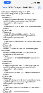
I have downloaded the file for Wildcamp but don’t get an option to ‘open in’

When I click the file I just get a load of code

Sorry for being technophobe 😬
 

Attachments

  • BF6DA1F0-DC98-4CD8-9DB1-FD042C1A0688.png
    BF6DA1F0-DC98-4CD8-9DB1-FD042C1A0688.png
    985 KB · Views: 107
Hello
I have downloaded the file for Wildcamp but don’t get an option to ‘open in’

When I click the file I just get a load of code

Sorry for being technophobe 😬
Do you have maps.me installed?
 
Hello
I have downloaded the file for Wildcamp but don’t get an option to ‘open in’

When I click the file I just get a load of code

Sorry for being technophobe 😬
What device are you using?
 

Users who viewed this discussion (Total:0)

Back
Top