Alternative to MS Autoroute for trip planning?

barryd

Full Member
Posts
16,870
Likes
31,847
I just realised my old 2013 version of Autoroute which I used to use quite a lot back in the day for Euro trip planning is not installed on this laptop and it will be a PIA to dig it out and install it.

Trying to find an alternative that can be used offline in the same way. Probably wont be too much of an issue now as most of the time we will have an internet connection so google maps etc will be fine.

Not interested in phone apps. Got to work on Windows 11 and got to work offline.
 
Osm android work 100% for me, takes a bit of setting up at first on a mobile or tablet, any onld 4g ph android 7 on works.
Only problem was over the irish border it went blank, android must be ulster unionist breed. 😂
So bought this and very very pleased with it, so simple to use, would have to be for me.
satnav.jpg
 
Last edited:
Sorry what is wrong with good old Google maps? We used it recently in the USA. As long as you can find some public wifi you can enter your route and download the map for offline use. It works just as being on line except it has no knowledge of any hold ups or accidents etc like the online version.

We had decided it was too complicated to try and get any form of phone coverage while in the USA. Also for phone calls we used whatsapp, again as long as you can find some wifi you can keep in touch.
 
Thanks folks but I don't think any of those ideas will work. As said, not interested in tablets or phones Trev, Via Michelin I used to use and its good but I don't think it will work offline on a laptop and Google maps is the same. Its not a biggie as I know will be able to use Magic Earth or Google maps offline on my phone but they are useless for proper planning. I need a 15" screen, mouse and keyboard.

Looks like I might have to find my old copy of Autoroute 2013. :D
Pity as always a problem for us all with differant use, best of luck.
 
I don't think it exists and God knows where I put the hard drive with the old Autoroute on. tried various suggestions from ChatGPT. All crap. I suspect it will no longer be required anyway. Shame as I used to love messing about with autoroute with all the POI in it in the back of the van on the laptop when on tour. I've pretty much got the first couple of months of the trip over the water planned anyway but already it changed today. Looks like we are going to the Black Forest in Germany now in the first week or so and not sticking to France which will pretty much Guarantee ill be in Annecy for Bastile Day! :LOL:
 
I don't think it exists and God knows where I put the hard drive with the old Autoroute on. tried various suggestions from ChatGPT. All crap. I suspect it will no longer be required anyway. Shame as I used to love messing about with autoroute with all the POI in it in the back of the van on the laptop when on tour. I've pretty much got the first couple of months of the trip over the water planned anyway but already it changed today. Looks like we are going to the Black Forest in Germany now in the first week or so and not sticking to France which will pretty much Guarantee ill be in Annecy for Bastile Day! :LOL:
Been to the black forest courtesy of HMG.
 
Osmand will do everything you need, but is iOS/Android only, so just cast your phone screen to your laptop if you absolutely have to access it from there.

Personally I'd invest in a largish Android tablet, fashion a dash mount and use it as your sat nav.

Or install an Android Auto-compatible head unit and cast Osmand from your phone.

All offline, and you still have all the hiking routes bike trails etc with you when out and about and lugging a laptop is impractical.

Morph
 
It does not get much of a mention but I have found inRoute https://inroute.com/

It has all sorts of great features for planning routes— when you start travelling it basically loads your chosen route in to Apple Maps - so needs an internet connection.

It’s available for iPhone/iPad and Mac laptops.

I use it like this: add all the points I am thinking would be nice to visit (you can add notes to them to hold details about why they are good, camo sites etc.) - blue blobs

Then decide which ones you want to actually put on a route - orange numbers.

Then you can let it order them for you and tell it things like what time of day you like to travel, when you want to leave a certain point.

When travelling and we want to change the route we just add one of the blue blobs in.

My wife and I can share routes as we do our research.

It’s not perfect but after trying many apps it’s the best we have found - so far!
 
Thanks all but I don't think what I want exists anymore. Least not for a laptop offline. I might even give up on resurrecting Autoroute (Assuming I can find it). Clearly I am in a minority that prefer to use a full size laptop over a phone or tablet. I really don't understand that though as you can do so much more and see so much more detail on a large screen, proper keyboard and mouse. I am hoping it wont be an issue anyway as I think we should be good 90% of the time for online connectivity and if not ill struggle on with offline Google Maps or Magic Earth on my phone.
 
I cannot see what all the fuss is about. I used Satnavs with the route and waypoints sorted out. When I was driving I never really looked at it. I listened to the instructions and the 'bings' when I was over the speed limit. :giggle: Before I set off on unfamiliar roads I also glanced at a paper Road Atlas to familiarise myself with the basics of the route for that day.

I have to say though, when I had the proper Garmin (motorhome version) I would often write down the main road numbers on a slip of paper and put it in the Sun visor. That was because the Garmin was either spot on, or totally useless. There was no inbetween. :rolleyes:
 
Thanks all but I don't think what I want exists anymore. Least not for a laptop offline. I might even give up on resurrecting Autoroute (Assuming I can find it). Clearly I am in a minority that prefer to use a full size laptop over a phone or tablet. I really don't understand that though as you can do so much more and see so much more detail on a large screen, proper keyboard and mouse. I am hoping it wont be an issue anyway as I think we should be good 90% of the time for online connectivity and if not ill struggle on with offline Google Maps or Magic Earth on my phone.
Magic earth is no way as good as the android version.
 
I cannot see what all the fuss is about. I used Satnavs with the route and waypoints sorted out. When I was driving I never really looked at it. I listened to the instructions and the 'bings' when I was over the speed limit. :giggle: Before I set off on unfamiliar roads I also glanced at a paper Road Atlas to familiarise myself with the basics of the route for that day.

I have to say though, when I had the proper Garmin (motorhome version) I would often write down the main road numbers on a slip of paper and put it in the Sun visor. That was because the Garmin was either spot on, or totally useless. There was no inbetween. :rolleyes:
Having a handy list of road numbers or big towns is always a good idea, as is looking at a proper atlas. Always did that until I first got a sat nav, didn't take me long to realise you can't rely on sat nav, and it will often mess up at the worst possible time. Back to a handy hand written list for the days journey.
 
I cannot see what all the fuss is about. I used Satnavs with the route and waypoints sorted out. When I was driving I never really looked at it. I listened to the instructions and the 'bings' when I was over the speed limit. :giggle: Before I set off on unfamiliar roads I also glanced at a paper Road Atlas to familiarise myself with the basics of the route for that day.

I have to say though, when I had the proper Garmin (motorhome version) I would often write down the main road numbers on a slip of paper and put it in the Sun visor. That was because the Garmin was either spot on, or totally useless. There was no inbetween. :rolleyes:

I don't think you and perhaps a few others maybe get what I want. I like to plot stuff with multiple way points, try different routes, look at terrain etc. So I might spend an hour messing about with that, working out distances, roads etc. Now without doubt the online tools to do that (on a laptop) are great. Google Maps, Streetview etc but you can't do it on a sat nav, a phone or a paper road map really at least not as well or as easily.

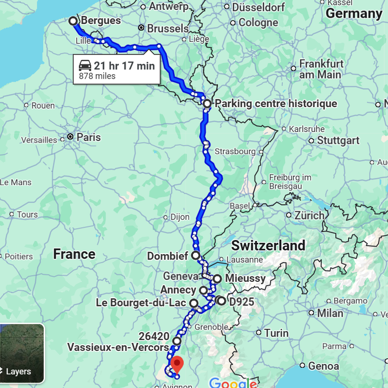
This is a crap example but you get the idea. Lots of way points. I might drag them around or try alternative routes and compare, or check altitudes etc. Easy on Google Maps but you could also do it on Autoroute "offline" which on mine showed all the Aires, Wild camping spots and a load of other stuff. If I had to sit and do that with a hand held phone or TomTom I would end up pitching it through the window at Pierre playing Boules.

 
Thanks all but I don't think what I want exists anymore. Least not for a laptop offline. I might even give up on resurrecting Autoroute (Assuming I can find it). Clearly I am in a minority that prefer to use a full size laptop over a phone or tablet. I really don't understand that though as you can do so much more and see so much more detail on a large screen, proper keyboard and mouse. I am hoping it wont be an issue anyway as I think we should be good 90% of the time for online connectivity and if not ill struggle on with offline Google Maps or Magic Earth on my phone.
I think you need to do what I did years ago. Move away from a laptop and use a tablet with a large screen, bluetooth keyboard and mouse.

I have my tablet mounted in a gooseneck holder clamped to a table edge. Doing it this way elevates the tablet to a comfortable height and ideal working distance.

I have two such tablets, the older and smaller screen device sits on the dashboard for use as a satnav. Its screen size means it's far enough away from me that I can read it clearly without glasses. I'm far sighted now due to age.

Tablets are WAY LESS energy hungry than any laptop which is a huge plus when you don't have limitless amounts of AC power!

Yeah thats progress! Get a tablet and pretty much make it into a laptop when I have an actual proper laptop! :LOL:

I remember when the first iPads came out yonks ago. The first thing people did after boasting how they wondered how they ever lived without them and how great they were was get keyboards, stands and mice for them, basically turning them into laptops! :D

Please excuse my sarcastic sense of humour but you have to laugh. :D

I really don't like Tablets. Probably because I have a big gob and too much to say. You need a proper keyboard for that.
Yes but remember the question you asked.

You want a large screen and offline route planning. That's not possible today on a laptop.

The solution is the one that I have offered.
 
Most people set out with a plan that changes quite quickly. Why people need to overthink a holiday is a complete mystery to me. Just head off with details of your first stop, when you get there you can take a minute or two to plan the route for the next day. It's a holiday, not a military operation. Just chill out and go with what life (or traffic, or weather, or road diversions) chucks at you. :giggle:
 
Most people set out with a plan that changes quite quickly. Why people need to overthink a holiday is a complete mystery to me. Just head off with details of your first stop, when you get there you can take a minute or two to plan the route for the next day. It's a holiday, not a military operation. Just chill out and go with what life (or traffic, or weather, or road diversions) chucks at you. :giggle:

Fail to prepare, prepare to fail!! :LOL:

We do a lot of travelling about on the bike though remember. So its extremely useful for that the night before you maybe go off somewhere for the day as sat nav on a scooter is tricky. All I have is Magic Earth or Google maps with a headset and its not 100% reliable. We also do a lot of mountains, big mountains so failing to prepare for those trips in the van can really ruin your day.

I get it from my dad though. He was a Headmaster and planned all the school trips with military precision. :D I have all our stops planned for the Euro trip for the first two months so far but then it all changed two days ago when Germany got added. :D
 
Back
Top